Global Lakes & Reservoirs Repository - GLR

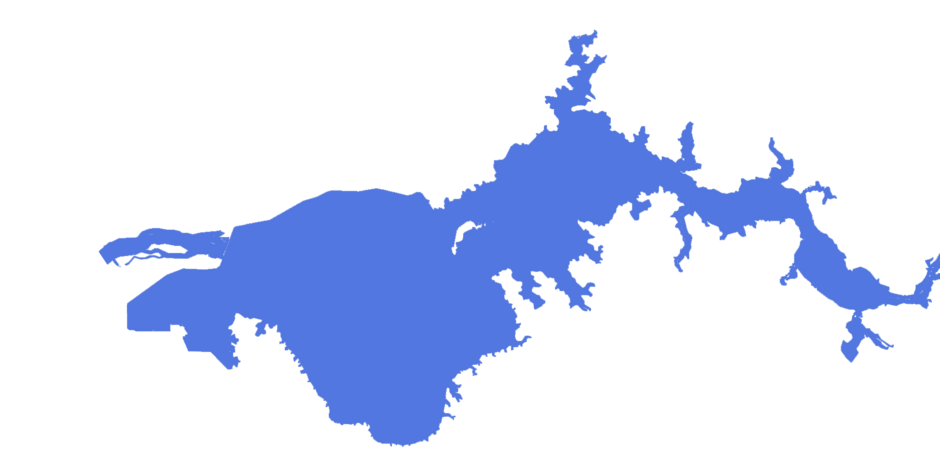
| State | Binacional ITUZAINGO / AYOLAS |
|---|---|
| River name | Paraná |
| sub-basin name | |
| Company name | Entidad Binacional Yacyretá |
| Latitude | 27°23'47"S |
| Longitude | 56°37'49"W |
| Construction Period | 1983-1994 |
| Total installed power(MW) | 1800 |
| Destination of Energy | |
| Historical Maximum discharge(m3/s) | |
| Mean discharge (m3/s) | 14500 |
| Historical minimum discharge (m3/s) | |
| Basin area (km2) | |
| maximum operational water level (m) | |
| extreme maximum water level (m) | |
| operational water level (m) | 82 |
| minimum operational water level (m) | |
| Total volume (m3) | 21000000000 |
| Net volume (m3) | |
| Length (km) | |
| Surface area at normal condition (km2) | 1600 |
| Downstream water level(maximum) (m) | |
| Downstream water level(normal) (m) | |
| Downstream water level(minimum) (m) | |
| Height of the spillway outlet (m) | |
| Height of the main dam (m) | 43 |
| Length of the main dam(m) | 69600 |
| Vaciemiento máximo / Capacidad de descarge del vertedor (m3/s) | 95000 |
| Tipo | CON COMPUERTAS |
| Número de Compuertas Total | |
| superfície | |
| Base | |
| Largo (m) | |
| Altura (m) | |
| Cota del tipo de ogiva | |
| Longitud de la cresta (m) | 808 |
| Número de unidades instaladas | 20 |
| Potencial nominal (MW) | |
| Tipo | |
| Ancho Total (m) | |
| Largo Total (m) | |
| Desnível (m) | |
| Referencia | Wikipedia: http://es.wikipedia.org/wiki/Represa_de_Yacyretá-Apipé |
| Otro información |